About Southwold
The history, geography, and character of Southwold.
Southwold is a small Suffolk town on a low cliff between the North Sea and the River Blyth, with about 950 residents recorded at the 2021 census and a summer population several times that. It is not a village pretending to be a resort or a resort pretending to be a village: it is a chartered town that has been trading, fishing, brewing and taking in visitors for a very long time, and it wears all of that at once. A working lighthouse stands among the houses. A brewery runs in the middle of the street plan. Six eighteenth-century guns point out to sea from a clifftop green. A hand-rowed boat carries people across the river mouth. None of it is staged.
History & Heritage
Almost an island
Look at Southwold on a map and the shape explains the town. The sea is to the east, the River Blyth curls round the south to the harbour at Blackshore, and Buss Creek runs across the north into the Blyth's marshes. That leaves one narrow neck of land, crossed at Mights Bridge, and for centuries a bridge there was the only connection to Reydon and the rest of Suffolk. A benefactor, Emma Lord, left money for a permanent bridge in 1524. The town's own museum puts it plainly: Southwold's ancient names, Suwald, Sudholda, Southwaud, Southwood, recall the woods nearby, but the place is characterised more by the waterways that surround it on every side. That geography is also why the town feels contained. You can walk its full boundary in a couple of hours, and once you have, the difference between Southwold and every other stretch of the Suffolk coast makes sense.
The fire, and why there are so many greens
In 1659 a fire destroyed most of Southwold in four hours. The Town Hall went, and the town records inside it, along with the market place, the prison, the shops, granaries and warehouses; three hundred families were made homeless and many stayed destitute for years despite donations from around the country. What was built afterwards was built differently. The open greens scattered through the town, South Green, East Green, North Green, St James's Green, Bartholomew Green, are not Victorian landscaping. They are early town planning: firebreaks, put in deliberately so that a fire could never again run the length of the place. It is the single most useful fact for reading Southwold's street plan, and it is why a town of under a thousand people has more open grass inside it than towns ten times its size.
Sole Bay, and the guns on the hill
The stretch of water in front of the town is Sole Bay, and on 28 May 1672 an Anglo-French fleet fought a Dutch fleet in it, within sight of Southwold's residents, who were put on alert in case they had to fight off a landing. Nearly four thousand seamen died. Cannonballs are still trawled up in fishing nets off this coast. Six eighteen-pounder guns stand on the clifftop green that takes its name from them, Gun Hill, pointing out over the bay; they were removed and buried during the Second World War and put back on new carriages afterwards. Southwold has been a front-line town three times in four hundred years: Sole Bay, then Zeppelin raids and naval shelling in the First World War, then mines on the beach, guns installed and beach huts scattered across the Common to deter enemy gliders in the Second, when high-explosive bombs killed thirteen residents and blew out the windows of St Edmund's Church.
Adnams, and a town that smells of malt
George and Ernest Adnams bought the Sole Bay Brewery in Southwold in 1872. The brewery site had been founded in 1818 and Adnams says brewing is documented on it back to the fourteenth century. The company is still here, still brewing in the middle of the town, and it has grown into the largest thing in Southwold by a distance: it owns The Swan and The Crown on the Market Place and High Street, the Sole Bay Inn, the Lord Nelson and the Harbour Inn, it distils gin, vodka and whisky at the Copper House Distillery on the brewery site, and it runs the town's public tours, including the one up the lighthouse. Southwold Bitter and Ghost Ship are on every bar in the district.
The lighthouse and the pier
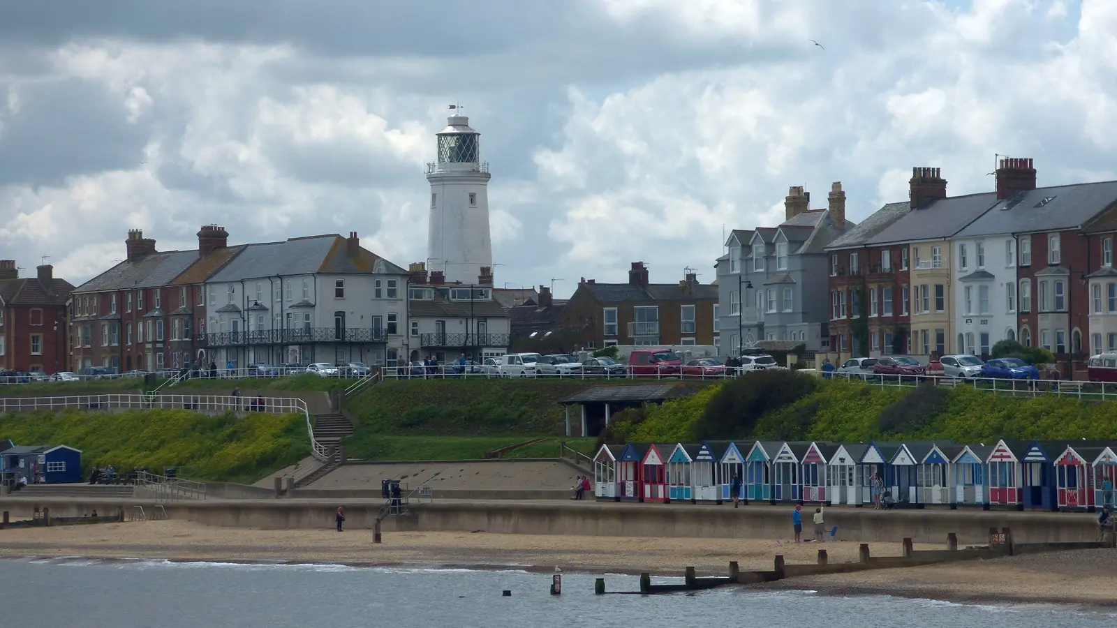
Southwold's lighthouse does not stand on a headland. It stands on St James's Green with terraced houses and a pub against its base, which is why it turns up in the background of every photograph taken here. Trinity House commissioned it in 1890 and it was automated and electrified in 1938; it is still an operational aid to navigation, and Adnams runs public tours up its 113 stairs. The pier runs 623 feet out into the North Sea from North Parade and carries a restaurant, a cafe, an arcade, shops and, under the deck, the Under the Pier Show: an arcade of home-made coin-operated machines built by the engineer and cartoonist Tim Hunkin, satirical rather than nostalgic, and the single most-remembered thing in Southwold. In high winds the pier closes those indoor attractions, which on this coast happens often enough to be worth checking before you set out.
The Blair family on the High Street
Richard and Ida Blair had lived in Southwold for more than a decade before they bought Montague House on the High Street in 1932, with a legacy from Ida's family. Richard was a member of the golf club and of the Blyth club, which did not admit tradesmen; Ida played bridge and ran the Copper Kettle tea room on Queen Street with her daughter Avril. Their son Eric Arthur Blair, who published as George Orwell, is commemorated by a small plaque on the front of the house, renewed by the Orwell Society in 2018. The house is private and the plaque is easy to walk past, which suits the town: Southwold does not make much of the connection, and the Blairs' Southwold, a small, respectable, club-membered place, is legible in his fiction whether or not the town enjoys it.
The railway that was
Between 24 September 1879 and 11 April 1929 a three-foot narrow-gauge railway ran from Halesworth to Southwold. It closed nearly a century ago and nothing replaced it, which is why the town's Station Road leads nowhere and why every visitor arriving by train today finishes the journey on a bus. The Southwold Railway Trust keeps the memory alive at Steamworks on Blyth Road, where volunteers are rebuilding rolling stock and a locomotive, with open days on published Sundays. It is a workshop you can walk around, not a service you can ride into town, and the distinction matters: there is no railway station in Southwold and has not been one since 1929.
Wildlife & Nature
Marine Life
Day-boat fish of Sole Bay
Southwold's small fleet works out of Blackshore on the Blyth and lands cod, haddock, plaice and skate among others; the Sole Bay Fish Company's own boats, Our Carol II and Suzie P, supply its harbour counter and its town-centre chip shop. Watching boats come in and gear being worked on the quay is a normal part of a harbour walk rather than a scheduled event.
Mornings at Blackshore, year-round
Seals off the beach
Seals are seen from the beach and the pier along this coast, usually as a head in the water rather than a haul-out. They are an incidental sighting here rather than a reliable one: the large Suffolk and Norfolk haul-outs are further north.
Autumn and winter, from the pier or the quieter beach north of it
Birdlife
Marsh and reedbed birds on Buss Creek
The brackish water and reed of Buss Creek and the Town Marshes on the town's northern edge draw sedge warblers, reed warblers, reed buntings, grasshopper warblers and water rails in the breeding season, as the interpretation board on the creek sets out. It is a five-minute walk from the High Street and almost nobody goes.
April to July for singing warblers
Waders on the Blyth
The tidal mud of the Blyth between Blackshore and the Bailey bridge feeds waders through the winter, and the walk along the north bank puts you level with them without a hide. Low tide is when there is anything to see.
Autumn and winter, around low tide
Passing seabirds off Sole Bay
Southwold faces due east into the North Sea, which makes the pier and Gun Hill workable seawatching points during onshore weather in autumn migration. Bring something to keep the wind off; there is no shelter on either.
Autumn, in onshore winds
Flora
Southwold Common
The Common on the town's western edge is open grassland used for cricket, golf and grazing rather than a manicured park, and it forms the inland half of the circuit round the town's boundary. The museum notes that beach huts were scattered across it in the Second World War to stop enemy gliders landing.
Late spring and summer