Walking the Wicklow coast: the Murrough, Glen Beach and Wicklow Head
Two coastal walks either side of the town that could not be more different: a flat, exposed shingle strip running north, and a clifftop path south with grey seals below it.
Wicklow Town has two coastal walks and they could not be less alike. North of the harbour the Murrough runs flat and open for kilometres. South of it the ground rises into low cliffs and a path picks its way along the top toward Wicklow Head. One is a stroll you can do in shoes with a coffee in your hand. The other wants boots and a look at the forecast. Between them they are the main reason to come here.
The Murrough: level, exposed, and the town's default walk
The Murrough is a long strip of shingle, grass and rock armour running north from Wicklow Harbour, with the Irish Sea on one side and the wet grassland and open water of Broad Lough on the other. Wicklow Town's own tourism site calls it the longest wetland on the east coast and describes it as a birdwatcher's site, and Wicklow County Council monitors its water quality as one of the county's non-identified bathing waters.
The walking is level, step-free and on compacted gravel and grass. Start at the Murrough car park, which is fifty cent for the entire day and sits beside the playground, the pump track and the skate park, then simply walk north as far as you feel like and turn around. Half an hour out and half an hour back is a pleasant hour. Going further gets you steadily more sky and steadily fewer people.
Two honest warnings. The first is wind. There is nothing between the Murrough and the Irish Sea, and a moderate easterly here feels considerably colder than the forecast temperature suggests, in July as much as in January. Take a windproof layer even on a bright morning. The second is water. People swim off the Murrough, and there is no lifeguard on it at any point in the year. The council's list of lifeguarded beaches covers Wicklow Harbour, Brittas Bay North, Brittas Bay South, Greystones South, Bray Promenade and Arklow, and the Murrough is not on it.
The Glen Beach Cliff Walk: four kilometres, 110 metres, and seals
The cliff walk starts from a free car park just under two kilometres south of the town centre off the Dunbur Road. The car park has about sixty spaces, picnic tables and bins, is open around the clock and costs nothing, and it fills on fine weekends.
It is usually described as a loop. Only the far end loops. Most of it is out and back along the clifftop, which means you walk the same ground twice and get the same view from the opposite direction, which is less of a hardship than it sounds. Reckon on about four kilometres and roughly an hour and a half at an unhurried pace, with about 110 metres of climbing spread across the route. A longer variant runs to around five and a half kilometres and continues south toward the old lighthouse towers on Wicklow Head.
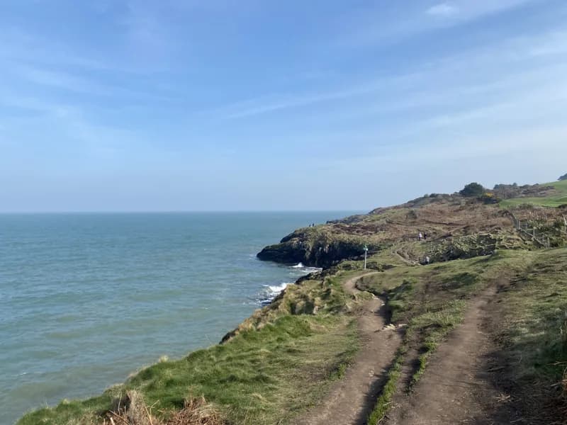
The route drops toward Glen Beach, a shingle cove, then climbs along the clifftop past Lime Kiln Bay to the headland at Bride's Head. The surface is grass, worn earth and exposed rock rather than a made path, and sections run close to an unfenced drop into the sea. Boots rather than trainers, and keep children close.
The seals are the reason many people come. Grey seals haul out on the rocks below the cliffs from roughly August through to April, and you will generally hear them before you spot them. The rule is simple and it is not optional: watch from the path, do not climb down to them, and keep dogs on a lead. A pup disturbed by people or dogs can be abandoned by its mother and will starve.
Wicklow Head and the three towers
Wicklow Head, about five kilometres south of the town, is the easternmost point of the Republic of Ireland, though not of the island, which reaches further east at Burr Point in Co. Down, and it carries three lighthouse towers on one headland. Two were built in 1781, an upper and a lower, deliberately paired so that mariners could not confuse Wicklow with the single lights at Howth Head and Hook Head. The lower was later replaced by the tower first lit in 1818, which is the working light today and has run automatically since 1994. The 1781 upper tower was gutted by lightning in 1836 and left standing as a daytime landmark.
That octagonal tower is now let by the Irish Landmark Trust as self-catering accommodation for four people, with octagonal rooms stacked vertically inside walls close to a metre thick and the kitchen at the top of 109 steps. There is no WiFi and no TV by design, the minimum stay is two nights, and it books out a long way ahead.
The working station itself is not open to visitors. What you come for is the headland, the towers and the drop to the water. The approach lane is narrow with limited turning space, so if you are already on the cliff path from Glen Beach, walking the extension is the better way in.
Putting a day together
The cliff walk in the morning and the Murrough in the evening is the shape of a good day here, with the town and lunch in between. That is roughly ten kilometres of walking in total, none of it technically hard, and it costs a car parking ticket and whatever you eat. If the weather turns genuinely nasty, the Murrough still works in a way the clifftop does not: it is level, it is close to the car, and you can turn back at any point. The cliff path in a strong easterly, above an unfenced drop, is not the day to be stubborn about.
Keep Reading
Wicklow Town: what it is, and what it is not
A county town with a working harbour, a gaol on the hill and no hotel in the centre. What Wicklow offers that Bray, Greystones and Glendalough do not, and the practical things that catch visitors out.
Food & DrinkEating and drinking in Wicklow Town
A small, mostly independent scene: one harbour-front restaurant worth booking, a bakery worth crossing town for, a brewery named after a ship, and the pub that is shut on Mondays and Tuesdays.
Planning a trip?
Explore restaurants, activities, accommodation, and more.