About North Berwick
The history, geography, and character of North Berwick.
North Berwick is a small seaside town on the south shore of the Firth of Forth, in East Lothian, about 30 kilometres east of Edinburgh. Its population was recorded at 7,840 in 2020. It is not, and this needs saying because sources confuse the two constantly, Berwick-upon-Tweed: that is an English town in Northumberland roughly 60 kilometres further down the coast. Say it the way people here do, BERR-ick, and the Gaelic form is Bearaig a Tuath. What defines the place is volcanic geology and a railway line: four old volcanic plugs stand offshore or behind the town, one of them carries one of the world's largest gannet colonies, and a branch line has put Edinburgh half an hour away since 1850.
History & Heritage
Four volcanoes and a hill
Everything visually distinctive about North Berwick is the hard core of an old volcano. North Berwick Law, the 187-metre cone standing directly behind the town, is a volcanic plug: the resistant vent-fill left standing after the softer rock around it was stripped away, in this case by ice moving east and leaving the long tail of softer ground on its lee side. The same story produced the islands strung out across the Firth in front of the town: Craigleith, the Lamb, Fidra and, furthest east and most dramatic, the Bass Rock. Look west from the Law on a clear day and you can see Arthur's Seat in Edinburgh, another remnant of the same volcanic province. It is the reason this stretch of coast looks like nowhere else in lowland Scotland, and it is why a town of under 8,000 people has a skyline.
A harbour, two bays and a High Street that still works
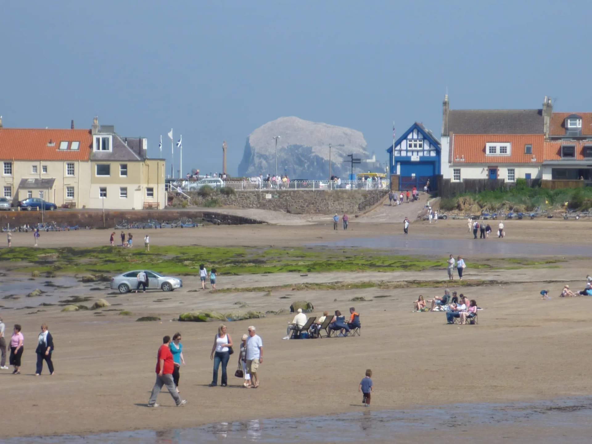
The old town sits on a rocky promontory between two beaches, with the harbour on the point. The harbour goes back to the twelfth century, when it served the ferry crossing to Earlsferry in Fife, part of the pilgrim route to St Andrews; today it is a small working harbour with creel boats, yachts, an RNLI lifeboat station and the Scottish Seabird Centre sharing the same headland. West Bay runs off to one side, backed by grass, the beach huts and the golf links. Milsey Bay, which everyone here calls the East Bay whatever the signs say, runs off the other, backed by Victorian seafront terraces. Between them, the High Street and Quality Street still carry a genuine mix of independents: a coffee roastery in a lane off the High Street, an artisan bakery, a gelateria going since 1991, a pharmacy, a post office. The town has a business association that argues with the council about parking, which is the surest sign of a high street that is still alive.
The Bass Rock
About three miles offshore, the Bass Rock rises out of the Firth as a sheer-sided volcanic stump. From roughly late winter it fills with nesting northern gannets, so many that the rock changes colour from dark grey to white when seen from the town. The colony has been counted by drone in recent years and the numbers tell a hard story: 51,844 apparently occupied sites in June 2023, down to 46,045 in July 2024 after highly pathogenic avian influenza swept through the colony in 2022, then back up to 52,459 in a survey flown on 3 July 2025 by the Scottish Seabird Centre and its research partners. The Rock has also been a fortress, a state prison and a lighthouse station; there are fortifications, a chapel and a foghorn on it still. Landings are possible only on a small number of licensed trips, run for photographers, from late March to early October. Everyone else sees it from a boat, from the shore, or through the Seabird Centre's cameras.
Castles east and west
Two Historic Environment Scotland properties sit within five kilometres of the town, and they are opposites. Tantallon Castle, four kilometres east on a clifftop headland facing the Bass Rock, is a single vast red sandstone curtain wall thrown across a promontory, the stronghold of the Red Douglas earls of Angus. Dirleton Castle, four kilometres west in a village of the same name, is a fortress and residence held by three noble families across four hundred years, entered over a timber bridge, and famous now for its gardens rather than its walls. Both currently carry restricted-access notices: at Tantallon there is no visitor access to the east tower staircase and the doocot, and at Dirleton none to the Guard House, the South Entrance and the De Vaux range. Check before you travel if a specific part of either is the reason for the trip.
Golf, without the reverence
East Lothian markets itself as Scotland's Golf Coast and North Berwick has two courses inside the town. The West Links, played by The North Berwick Golf Club, is one of the oldest courses in Scotland, and the 15th is the original Redan, the template hole that architects have copied on courses across the world ever since. Visitors play six days a week; Saturday is a members' day. The Glen, on the East Links headland beyond the harbour, is the town's other course, clifftop, cheaper and generally easier to get a tee time on, with the Bass Rock straight ahead from several holes. Neither requires you to care about golf to enjoy walking near them, and the public coast path crosses both.
The whalebone arch, and the honest version of the story
An arch of whale jawbones has stood on the summit of North Berwick Law, on and off, since 1709. The set that most people remember collapsed in June 2005 after decades of weather, and in June 2008 it was replaced with a fibreglass replica, which is what stands there now. It is worth being straightforward about that rather than quietly implying otherwise: the arch is a copy, everybody local knows it is a copy, and it is still the emblem on the skyline that tells you which town you are looking at from the train. Beside it are the ruins of a Napoleonic-era signal station, one of the chain built to watch for a French invasion that never came.
Wildlife & Nature
Marine Life
Grey seal
Seen hauled out on the rocks around the harbour and the islands, and regularly spotted from the boats. The Firth of Forth holds a substantial population and the islands off North Berwick are among their resting places.
Year round, most reliably from a boat or from the harbour rocks at low tide
Bottlenose dolphin
Not guaranteed and never promised by the operators, but the boat trips out to the three islands do sometimes encounter dolphins in the Firth. Treat any sighting as a bonus rather than a reason to book.
Spring and summer, from the boats
Birdlife
Northern gannet
The reason the town is on the ornithological map. The Bass Rock carries one of the largest colonies of northern gannets anywhere, counted at 52,459 apparently occupied sites in a drone survey on 3 July 2025 by the Scottish Seabird Centre and its research partners. From the shore they are a white haze over a dark rock; from a boat they are overhead in their hundreds. The species name, Morus bassanus, is taken from the Rock itself.
Spring through to early autumn, with the boat season running roughly late March to early October
Atlantic puffin
Puffins nest on Craigleith, the nearest island to the town, and are the target of the short Puffin Express boat trip. Their season on the island is earlier and shorter than most visitors assume, so book early in the summer rather than late. The Scottish Seabird Centre's SOS Puffin project exists because invasive tree mallow was crowding out their burrows on Craigleith and the Lamb.
Late spring into early summer, from the boats
Guillemot and razorbill
Both nest on the cliffs of the islands off North Berwick and are routinely seen on the three-island boat trips alongside the gannets and puffins. Shags are common on the Bass Rock itself.
Spring and early summer
Flora
Tree mallow
Worth knowing about as a problem rather than an attraction. This tall, fast-growing plant took over large parts of Craigleith and the Lamb and blocked the burrows puffins need, which is what the Scottish Seabird Centre's SOS Puffin volunteer project was set up to reverse. You can see the difference on the islands from the boats.
Summer, when it is in full growth on the islands
Marram and dune grassland
The grass holding the dunes together behind West Bay and out towards Yellowcraig, and the reason the marked paths matter: marram is what stops the dunes walking inland. The same rough grassland covers the flanks of the Law.
Year round